Blackwell Parish 1841
The first British census was conducted in 1801 (giving details of numbers of people in households, with few further details). It was only from 1841 that information concerning every individual in the land was recorded, although significantly less information was needed than on the 2011 32 page census return.
The 1841 census recorded number of households, the names of the residents, their ages and whether male or female; also their occupation and whether born in the county of current residence.
Blackwell Parish in 1841 was very different to today, as the following notes will demonstrate.
 From the first page of the official census it appears that there were a number of people working on the listings: Families were recorded by JJR , Houses by JE, and Ages by H Wakeford.
Imagine these enumerators walking the parish in the order of the listing, beginning at the corner of Hilcote lane and Berristow lane, moving through Hilcote , on to Hill Top ( at the end of Whites Lane), then to West Pasture House towards what we know as Westhouses, and back to Scanderlands. They then walk up to Newton, Newton Green, across to Wrag (Huthwaite) Lane, to Twinyards ,along to Blackwell ( now Old Blackwell), and down the hill to Lane End, recording details of 99 households with a population of 477.
Households and Population
These are listed as the following table:
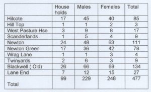
A contemporary map shows Newton Green to be the development on the left side of Main St stretching from Hall Lane to New Street, on what was possibly lands farmed by Green Farm. The 1841 census households of Sarah King, John Freeman, John Boot and George Freeman listed under Newton Green are situated at the junction of Hall Lane and Littlemoor lane on the 1839 Tithe map .
Wrag Lane is what we now know as Huthwaite Lane. Other lanes between Wrag lane and Littlemoor and Cragg Lanes were Redbarn Lane, Town Lane and Greendale Lane which ran across from Littlemoor to Wragg Lane and Pipes Farm, Old Blackwell. Parallel to and East of Greendale Lane was Cow Lane, now under the M1 motorway.
Family Names
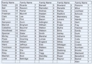 Within the 99 households there are 101 family names, and 20 of the family names account for 50% of the population. The first five family names account for 20% and some are still familiar in Blackwell today: In the chart following the 101 family names are shown with the number of folk who bore that name. It should be noted that spellings of names varied according to who was writing, and some handwriting is difficult to make out.
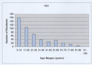
Ages of the population
This chart shows the ages of the population in 10 year bands. 56% of the whole population are 20 years old and younger, 70 % below the age of 31 years.
Occupations
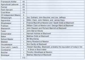 Listed here are the occupations of the population as detailed in the census return. However the total is only 170 from a population of 477; The fact that children 10 years and below numbered 160 accounts in part for this but the main reason appears to be that occupations of wives and children were not reported unless they were working outside of the home. It is known for example that Framework knitting occupied all members of the family, and Farmers wives and children would also be working in the family farm. In both cases only the head of the household has his occupation listed. There were very few over the age of 13 who would not be employed in some way.
Only one child is listed as a pupil and he was a boarder at School Master Mr William Mountenay’s home. Mr Sydney Storer’s History of Blackwell Church tells us that Mr Mountenay was the School Master/ Teacher at a small building near the Church’s Lych Gates; The lords of the manor had provided the school in 1835 , and granted £20 per annum for which 12 children were to be taught free. The census gives us no information as to which 12 children enjoyed this benefit, or how the vast majority of the children received any formal education.
The main activity in the parish remains as Farming and Framework Knitting. At this time Coal Mining was a minor occupation with only 15 employed. These 15 would be working in the small pits in the area, perhaps Old Blackwell Colliery south of Pasture Lane Hilcote, or Old Hucknall Colliery just over the border in Huthwaite.
Note that there is no Minister of the church listed. Blackwell’s St Werburgh shared it’s vicar and had a dispensation that he may live outside the parish. In 1841 the vicar was Dr Leeson Cursham who travelled on horseback from Mansfield to conduct the services.
Born in Derbyshire?
Of our Census population of 477, there were 426 born in Derbyshire and 51 from out of county.